


Laotian Chronicle 4/6
By Lt. Colonel (Ret.) Antoine Marquet
January 24, 2024 (still)
The road follows, for three-quarters of its length, the Pak Ou River, a tributary of the Nam Ou, itself a tributary of the Mekong. Suddenly, the driver leaves the main track and takes a road to the right towards Khouang Rip, 7 km south of Khouang Kouei. After a few hundred meters, we arrive in a small hamlet where the inhabitants are joyfully celebrating an event that we discover is the wedding of the village chief's daughter.
We are welcomed with plenty of beer and small glasses of rice wine. In this general merriment, we dance with them, drink with them, and eat with them. Some offered us their homes, refilled our food and drinks… in my bowl of soup, I saw two balls of meat that my companions, after I ate one, quickly identified as dog testicles! In fact, they were pieces of grilled pig stomach! I had seen this organ grilled on a barbecue in Mouang Khoua, but… doubt remained!
The question now arose of how to leave this village without offending the kind villagers who had so generously welcomed us. Jacky had a good idea. Without saying a word to anyone, he went to get a case of beer from our truck and offered it, triggering renewed jubilation, but further libations kept us glued to our stools. It was Raoul who found the right solution. He stood near the disc jockey and called over the village chief to give him a wad of cash intended for the village or the bride—we don't know—but amidst applause, we were able to return to our truck despite a few attempts by the locals to give us more water.
The small community watched us leave with regret, and we remained deeply moved by this warm gesture.
Back on the main road, we finally reached the geographical point marking the entrance to the large valley where Cabaribère deployed his units. We located it using the War Diary, Commander Cabaribère's report, US Army maps provided to us by Jean-Luc Martin through our friend Jean-Yves Gourin, and satellite imagery. It is at this precise spot that we are holding a small ceremony in memory of our ancestors, dead and forgotten by all.
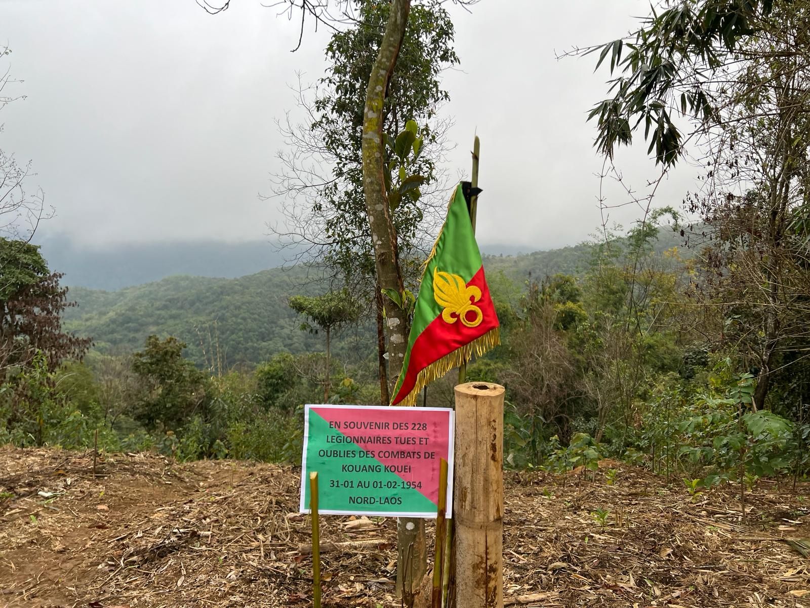
We brought our green berets, Baillaud his red beret, Jacky his veterans' pennant with its beautiful golden grenade on a background in our colors; a small sign, mounted on two bamboo poles, read:
"In memory of the 228 legionnaires killed and forgotten in the fighting at Kouang Kouei, January 31 to February 1, 1954, Northern Laos."
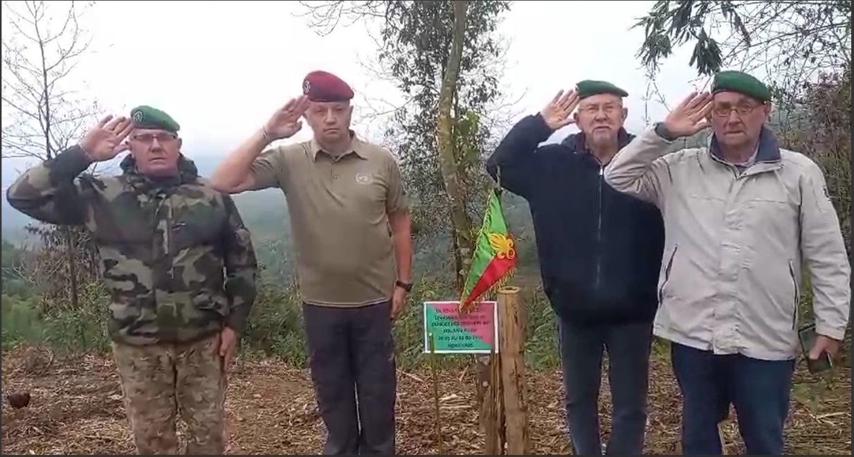
Then, we saluted and commanded "To the Fallen" to observe a minute of silence, which ended with the notes of "Le Boudin," recorded by Jean-Pierre on his phone.
"Sleep in the grandeur of your sacrifice,
Sleep, may no regret haunt you,
Sleep in this vast and liberating peace,
Where my mourning thoughts will visit you."
Stubborn anti-militarists or the indifferent might have found this small ceremony ridiculous. And yet, for us, it was a deeply moving and meaningful experience, for in the depths of the valley, already enveloped by mist, we paid tribute to our comrades, our veterans, the dead and forgotten. Our dead without shrouds.
We wish to extend our special thanks to our comrade, General Jean Baillaud, former commanding officer of the 1st RCP, who, like us, stood in silent reflection, deeply moved by the memory of these brave men who lost their lives there due to a misinterpretation of a message.
We know that two or three months after these deadly battles, a battalion of the 2nd REI passed through, and its legionnaires buried what remained of our unfortunate veterans as best they could. The cold was setting in, and Jacky, well-equipped despite the security measures in the train stations, offered us some very comforting hot coffee. Back to Mouang Khoua. In the evening, before dinner, we visited a bistro run by a young Frenchman who has lived there for nine years (!). The guy isn't even 30! To live in a small town with no distractions in the depths of northern Laos, you need nerves of steel. We had a beer and would have gladly eaten, but for reasons that remain unclear to us, he's more or less stopped serving food at his bistro.
So we had dinner in the small esplanade where we have breakfast. Rustic but very good Laotian cuisine.
January 25, 2024
Visit to the battle sites in Mouang Khoua, and in particular the three strongpoints Alpha, Pi, and La Souricière.
Up very early, Jean-Pierre and Jacky went to La Souricière, which Jean and I didn't visit. The Mouang Khoua post is located at an altitude of 400 meters in this very mountainous region of northern Laos, 80 km from Dien Bien Phu as the crow flies but 100 km by track. It is a veritable isolated spot dominated by impressive peaks.
It was inevitably on the route of the Viet Minh troops coming from North Vietnam when they launched an offensive on Luang Prabang. The Nam Ou River, which flows through it, runs through steep gorges where the surrounding peaks can reach 1,700 meters in altitude over a very short distance. Coming from the west, the small Nam Pak River, which runs alongside the track leading to Mouang Xai for a long stretch, flows into the Nam Ou at Mouang Khoua.
The outpost is therefore located at the confluence of the two rivers. Travel is measured not in kilometers but in hours of walking due to the challenging terrain. To give you an idea of what hiking in this region entails, Google Maps shows a positive elevation gain of 730 meters for the 9-kilometer section from Mouang Khoua to Kouang Khouei.
Due to the altitude, the temperature is very cool at night and moderate during the day during the dry season in January and February. The outpost consisted of three strongpoints, spaced 200 meters apart, that could support each other. The strongpoint known as "The Mousetrap" was established on a rise north of the Nam Ou River and overlooked the village at the time.
Stretches Alpha and Pi were constructed on two rises south of the confluence of the Nam Pak and Nam Ou Rivers. A suspension bridge, which did not exist at the time, connects the two strongpoints.
The Viet Minh troops used long woven bamboo mats to cross the river, which they laid on sandbanks or lined with plastic jerrycans that served as floats.
The afternoon was dedicated to visiting Sop Nao, 40 km away, an old track connecting to Dien Bien Phu.
To be continued...